Boracay is an island of the Philippines located approximately 315 km (196 mi) south of Manila and 2 km off the northwest tip of Panay Island in the Western Visayas region of the Philippines. Boracay Island and its beaches have received awards numerous times. Boracay was awarded in the "Travelers' Choice 2011" by TripAdvisor as the second best beach (out of 25) in the world. Boracay made a debut appearance on the Top 10 Islands list in the Travel + Leisure travel magazine World's Best Awards 2011, ranking fourth.
The island comprises the barangays of Manoc-Manoc, Balabag, and Yapak (3 of the 17 barangays which make up the municipality of Malay), and is under the administrative control of the Philippine Tourism Authority in coordination with the Provincial Government of Aklan.
Boracay Island Philippines History
Boracay was originally home to the Ati tribe. Boracay is part of Aklan Province, which became an independent province on April 25, 1956.
In the late 1800s the island was "discovered" by Sofia Gonzales Tirol. She and her husband Lamberto Hontiveros Tirol, a town judge on nearby Panay island, took ownership of substantial properties and began to clear and develop the island.
Boracay Island was relatively unknown until tourism began to develop in the 1970s, after the movie Too Late the Hero was filmed on locations in Boracay and Caticlan. In the 1980s, the island became popular as a budget destination for backpackers,an by the 21st century, had grown to become one of the major tourist destinations in the Philippines.
When you visit Philippines, don't forget to include Boracay in your iterinary. Read more info about Boracay
Showing posts with label Philippines. Show all posts
Wednesday, January 11, 2012
Wednesday, November 9, 2011
North & South Cay Islands, Busuanga, Palawan, Philippines
These are the beautiful islands called North & South Cay Island located in Busuanga, Palawan, Philippines.
Imagine, if you see a 300 meter stretch of pure white sand beachfront surrounded by towering limestone cliffs and majestic coconut palms, a postcard perfect tropical waters teaming with rainbows of aquatic life and eleven historically important World War II Japanese ship wrecks just minutes away from your doorstep.
Too good to be true? That's what they all say. As you can in the pictures of this island. It's amazing.
Imagine, if you see a 300 meter stretch of pure white sand beachfront surrounded by towering limestone cliffs and majestic coconut palms, a postcard perfect tropical waters teaming with rainbows of aquatic life and eleven historically important World War II Japanese ship wrecks just minutes away from your doorstep.
Too good to be true? That's what they all say. As you can in the pictures of this island. It's amazing.
Tuesday, June 14, 2011
The Island Of Bohol Philippines
Bohol is an island province of the Philippines located in the Central Visayas region, consisting of Bohol Island and 75 minor surrounding islands. Its capital is Tagbilaran City. With a land area of 4,117.26 square kilometres (1,589.68 sq mi) and a coastline 261 kilometres (162 mi) long, Bohol is the tenth largest island of the Philippines. To the west of Bohol is Cebu, to the northeast is the island of Leyte and to the south, across the Bohol Sea is Mindanao.
The province is a popular tourist destination with its beaches and resorts. The Chocolate Hills, numerous mounds of limestone formation, is the most popular attraction. Panglao Island, located just southwest of Tagbilaran City, is famous for its diving locations and routinely listed as one of the top ten diving locations in the world. Numerous tourist resorts dot the southern beaches and cater to divers from around the world. The Philippine Tarsier, considered the second-smallest primate in the world, is indigenous to the island.
Boholanos refer to their island homeland as the "Republic of Bohol" with both conviction and pride. A narrow strait separates the island of Cebu and Bohol and both share a common language, but the Boholanos retain a conscious distinction from the Cebuanos. Bohol's climate is generally dry, with maximum rainfall between the months of June and October. The interior is cooler than the coast.
It is the home province of Carlos P. Garcia, the eighth president of the Republic of the Philippines (1957–1961) who was born in Talibon, Bohol.


Today, Bohol is one of the top tourist destinations in the Philippines. There are many nice places in Bohol that attract the tourist such as the white beaches, caves, chocolate hills, Pamilacan island, floating restaurant in Loboc, historical landmark like the "Blood Compact" site in Tagbilaran City, Old Churches in many towns of Bohol like the one found in Baclayon, Loboc, etc.
The province is a popular tourist destination with its beaches and resorts. The Chocolate Hills, numerous mounds of limestone formation, is the most popular attraction. Panglao Island, located just southwest of Tagbilaran City, is famous for its diving locations and routinely listed as one of the top ten diving locations in the world. Numerous tourist resorts dot the southern beaches and cater to divers from around the world. The Philippine Tarsier, considered the second-smallest primate in the world, is indigenous to the island.
Boholanos refer to their island homeland as the "Republic of Bohol" with both conviction and pride. A narrow strait separates the island of Cebu and Bohol and both share a common language, but the Boholanos retain a conscious distinction from the Cebuanos. Bohol's climate is generally dry, with maximum rainfall between the months of June and October. The interior is cooler than the coast.
It is the home province of Carlos P. Garcia, the eighth president of the Republic of the Philippines (1957–1961) who was born in Talibon, Bohol.


Today, Bohol is one of the top tourist destinations in the Philippines. There are many nice places in Bohol that attract the tourist such as the white beaches, caves, chocolate hills, Pamilacan island, floating restaurant in Loboc, historical landmark like the "Blood Compact" site in Tagbilaran City, Old Churches in many towns of Bohol like the one found in Baclayon, Loboc, etc.
Labels:
Bohol,
Philippines
Wednesday, May 25, 2011
El Nido, Palawan Philippines
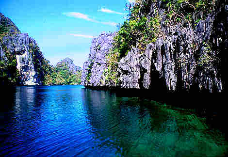
El Nido is a first class municipality and managed resource protected area in the province of Palawan in the Philippines. It is about 420 kilometres (260 mi) southwest of Manila, and about 238 kilometres (148 mi) northeast of Puerto Princesa, Palawan’s capital. See some of the beautiful views of El Nido, Palawan Philippines below:


Places of interest
From the towering marble cliffs and enchanting lagoons to its 100 white sandy beaches and lush jungle, El Nido is one of the top tourist destinations in Palawan, which is often referred to as the Philippines' Last Frontier. In the November–December 2007 issue of the National Geographic Traveler's magazine, Palawan was chosen as one of the best travel destinations in the world, and particularly, it recommended El Nido and the Calamianes Islands.
Article source: http://en.wikipedia.org/wiki/El_Nido,_Palawan


Places of interestFrom the towering marble cliffs and enchanting lagoons to its 100 white sandy beaches and lush jungle, El Nido is one of the top tourist destinations in Palawan, which is often referred to as the Philippines' Last Frontier. In the November–December 2007 issue of the National Geographic Traveler's magazine, Palawan was chosen as one of the best travel destinations in the world, and particularly, it recommended El Nido and the Calamianes Islands.
Article source: http://en.wikipedia.org/wiki/El_Nido,_Palawan
Labels:
El Nido,
Palawan,
Philippines